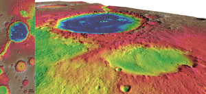


The primary scientific goal of NASA’s Mars Science Laboratory (MSL) rover mission, which is scheduled for launch in the fall of 2011, is to assess the present and past habitability of Mars. High-resolution digital terrain models (DTMs) of regional-scale extent and with a horizontal resolution (i.e. grid spacing) of 50 m can provide valuable information for addressing key questions related to the regional geologic and morphological context of the sites. This is suggested in particular for addressing layer attitude geometries, slope properties, and the morphologies of small topographic features (like channels and scarps with horizontal dimensions of few hundred meters to few kilometers). DTMs for each of the current MSL prospective landing sites selected following the 3rd MSL Landing Site Workshop in September 2008 have been produced at the Institute of Planetary Research of the German Aerospace Center (DLR). The images on this page show shaded relief maps and perspective views with color-coded heights generated from these digital terrain models.
The DTMs have been derived from stereo information for the areas of all available datasets of the High Resolution Stereo Camera (HRSC) of ESA’s Mars Express mission up to orbit #7422 (acquired in October 2009) and cover an area of about 0.55 Mio km2. HRSC is the first sensor system with built-in stereo capabilities that has been included in a planetary orbiter mission. DTM generation has been built on the methods and procedures applied by DLR for deriving archival Mars Express HRSC DTMs for all stereo image tracks, which are available via the PDS and PSA data systems. In addition, techniques for integration of multi-orbit stereo height measurements have been applied.
Download (PDS format):
References:
Scientific papers making use of the data products should reference the following, where also further details on the MSL landing site DTMs and HRSC DTM generation can be found:
Gwinner, K., et al. (2009). www.asprs.org/publications/pers/2009journal/september/abstracts.html
Gwinner, K., et al. (2010). www.lpi.usra.edu/meetings/lpsc2010/pdf/2727.pdf
Information on MSL landing site selection can be found in:
Golombek, M., et al. (2010) www.lpi.usra.edu/meetings/lpsc2010/pdf/2407.pdf
More general information on HRSC and the Mars Express HRSC experiment can also be found in:
Jaumann, R., et al. (2007) www.sciencedirect.com/science
Neukum, G., et al. (2004) sci.esa.int/science-e/www/object/doc.cfm
Last update: 04/05/2010 14:09