The Imaging Science Subsystem (ISS) onboard the Cassini spacecraft acquired many high-resolution images (<1km per pixel) during close flybys in the nominal mission phase at the major icy Saturnian satellites (Mimas, Enceladus, Tethys, Dione, Rhea, Iapetus and Phoebe). These images were combined into global mosaics, which are the basis of high-resolution cartographic atlases (Roatsch et al., 2009).
In addition to ISS the Visual and Infrared Mapping Spectrometer (VIMS) obtained new spectral data of the icy satellites of Saturn. VIMS operates in a spectral range from 0.35 to 5.2 mm, generating image cubes in which each pixel represents a spectrum consisting of 352 contiguous wavebands. As an imaging spectrometer, VIMS combines the characteristics of both a spectrometer and an imaging instrument. This makes it possible to analyze the spectrum of each pixel separately and to map the spectral characteristics spatially, which is important to study the relationships between spectral information and geological and geomorphologic surface features.
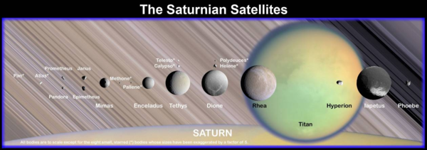
Especially in case of the largest Saturnian satellite Titan the remote sensing instruments aboard the Cassini spacecraft revealed a wealth of new data of the formerly unkown surface. The maps of Titan’s surface presented here were achieved by the remote sensing instruments of the Cassini spacecraft during the nominal Cassini mission from 2004 until 2008. All maps are published in Stephan et al. (2009).
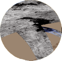
The Cassini Radio Detection and Ranging (RADAR) Mapper plays a significant role in investigating the surface of Titan. This multimode radar instrument is able to probe the optically inaccessible and therefore formerly unknown surface of Titan. The four different modes of the instrument (Synthetic Aperture Radar (SAR) imaging, Altimetry, Scatterometry and Radiometry) allow surface imaging as well as topographic mapping (Elachi et al., 1991, 2004) nearly unaffected by atmospheric contributions.
Last update: 17/06/2011 12:26